
View Rating - 10 out of 10!
Distance - Maximum distance 11 miles round trip - But you can go out and back as far or as short as desired.
Elevation Gain - 350 feet
Highest Point - 6600 feet
Note that dogs are not allowed on the trail.
Rubicon Trail runs from Rubicon Point at D.L.Bliss State Park on the West Shore, south to Emerald Bay and, for those with energy, back along the north side of the bay to the Vikingsholm Castle.
You can hike it from either direction. If you arrange to be dropped off or picked up, you can go one way - about 5.5 miles from the D.L.Bliss parking lot trailhead to the Vikingsholm parking lot on the highway above the castle. If you go round trip, you double your distance. If you want to trim that a couple of miles, you can go round trip from Bliss to the Vikingsholm Castle and back and skip the walk from the castle up to the Vikingsholm Castle parking lot.
Note that D.L. Bliss State Park is closed for the season, so if you want to hike the northern portion of the Rubicon Trail hike, you'd have to access it from the highway or from Emerald Bay to the south.
Be sure to bring lots of food and water in case you decide to hike farther than your initial plan. Also arm yourself with good maps, whether from a hiking guidebook or from Google Maps.
 |
| This is the highway sign marking the park entrance. |
 |
| Drive all the way into the park, staying to the right. You'll see this sign marking the trailhead. |
 |
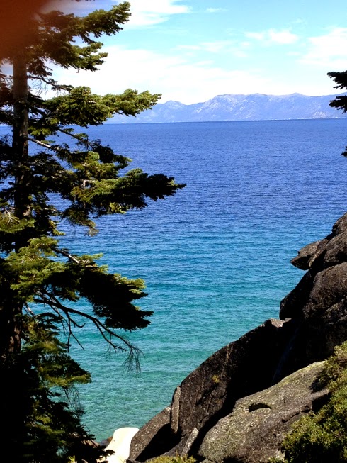
| From the very beginning of the hike, you'll look down at the amazing color of the water, caused by the great depth of the water. You're standing on the top edge of a cliff that goes 1200 feet straight down into the water. |
 |
| In places, the trail goes along vertical rocks. Don't worry, the railing is strong. |
 |
| Here's looking back at one of the rocks you have to duck under. |
 |
| Here is a place you can look straight down into that astonishing blue. |
 |
| There are some spectacular coves. |
 |
| In the distance to the southeast, you can see the ski runs of Heavenly. |
 |
| Here's a Sugar Pine, heavy with the world's biggest cones. (The cones grow up to 24" long.) Do you suppose this tree is so fertile because it's looking at the world's greatest view? |
 |
| We found a great lunch spot. But PLEASE don't climb out onto the rocks unless you are sure-footed. If you fell, it would be your last fall. Note the kayaks down on the water. |
 |
| In the distance to the south, you can see all the way to Steven's Peak. |
 |
| Looking down on trees from above with that blue backdrop... Wow. |
I think Todd's Tahoe Hit was one of his best. I loved the "twists and turns" at the end, and the totally unexpected killers revealed. I also continue to appreciate Borg's humorous banter between key characters.
ReplyDelete