Showing posts with label Kayaking. Show all posts

Sunday, July 23, 2017

Best Kayaking In Tahoe - Sand Harbor

If you've ever spent time in Tahoe, you probably know that Sand Harbor State Park, on the East Shore of the lake just south of Incline Village, is one of the all-time great spots for beach stuff, water stuff, view stuff, landscape painting stuff, and even theater stuff (Shakespeare On The Beach at the amphitheater).

The park is comprised of a curved spit of land with amazing coves and beaches and foot paths.

If you've never been to Tahoe, check it out when you get here. Bring a picnic lunch and be prepared for an amazing experience.

Launching a kayak at Sand Harbor is extra special because of all of the above.

First, make certain you have your boat inspection sticker/paperwork.

While you can park in any of the lots and carry your kayak to the shore, the easiest way is to park in the boat-launch lot. (There are two entrances to Sand Harbor. The boat launch is at the north entrance.)

Much of the year, you can rent kayaks right on the beach next to the boat launch.

It is glorious to simply paddle around the area. For experienced paddlers, you can go up the shore to the north and paddle along the fabulous houses of Lakeshore Blvd. in Incline Village. This is where the billionaires have their lake cottages that often sell at upwards of $50 million.

You can also go the other way and paddle south down to the Thunderbird Lodge which San Francisco playboy George Whittel built in the '30s. George had a thing for fast boats and cars and exotic animals. (He kept his pet lion Bill at his 40,000-acre estate on the East Shore of Tahoe.)

The lodge, which is actually a stone castle, is now part of the Nevada State Park system. One of the closest views is from your kayak. Enjoy!

Here's a photo tour from our kayak (last fall when the water level was lower than it is now).


Sunday, October 9, 2016

Best Kayaking In Tahoe - Fannette Island

Look carefully, there's an island hiding in front of that wall of rock! And if you look very close at the top of the island, you can see the square tea house that was built in 1929.

Fannette Island, the only island in Tahoe, is in Emerald Bay. It is where Captain Dick Barter, Tahoe's first year-round resident, spent time back in the 1860s. It is also where the heiress Lora Knight - after she built the Vikingsholm Castle on the shore of Emerald Bay - built a stone tea house back in 1929. She lived in the castle during the summers. During the day, she had her butler row her and her house guests out to the island to take tea. When you see the pictures below, you'll see why.

In the middle of September, while the weather was still glorious but the tourist rush was over, we kayaked out to Emerald Bay and visited Fannette Island. (See my previous blog post.)

While you can get to Fannette Island on most any boat, a kayak or canoe allows you to paddle right up to the rocky shore and step out onto dry land.

Here are the pics:

Like us, the paddlers in the red kayak are looking for a place on the island to make landfall.

There are lots of perfect coves in which to find shelter.

We found a perfect little Kayak Garage/Boathouse.

Once on the island, you can look out toward the mainland shore. Vikingsholm Castle is hidden in the trees.

A view of the mainland, framed by an ancient tree.

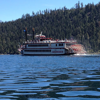
Zoom your camera in on the M.S. Dixie sternwheeler as it arrives at the Vikingsholm Castle. If you look close, you can see the castle in the trees just off the bow of the boat.

Fannette Island is about 150 feet tall. If you turn around to the east, you'll see the tea house at the top of the island.

Lora Knight's workers carved steps into the natural rock, making them look timeless and like something out of an epic ancient fantasy.

As you get close, the tea house dominates the island. Although it no longer has a roof, the stone walls are just as they were 90 years ago.

This view is looking down from just outside the tea house. The rock on the north side of the island is near-vertical, and you can see far down into the water.

Step inside the tea house and look out the picture windows. Have you ever seen a more perfect view with which to enjoy your tea?!

As we leave the island on our kayak, the Dixie cruises on past us.

Visiting Fannette Island by kayak or canoe is a singular experience you will never forget. I think it belongs near the top of the list of things to do in Tahoe.

Sunday, September 25, 2016

Best Kayaking In Tahoe - Emerald Bay

Emerald Bay is probably the single most important "Must See" place in Tahoe. Surrounded by 3000-foot walls of mountains, with the Vikingshom Castle at its tip, populated by Bald Eagles and Ospreys, and filled with deep water as clear as a swimming pool, Emerald Bay is at the top of your list of things to see.


This is Emerald Bay from above on the Bayview Hike. The island in the middle is Fannette Island, Tahoe's only island. I'll discuss it in my next blog post.

Most people see Emerald Bay by car. While that is good, and you'll love the experience, why not experience it from down on the water!

This is the view looking into Emerald Bay from the main body of Lake Tahoe.

Nearly any boat can get you to Emerald Bay, but I recommend human-powered craft, a kayak or canoe. Paddle craft are the best way to appreciate the sounds of the wilderness and smell the fresh air scents of wildflowers and pine trees. If you don't have a kayak, there are many places you can rent them, including, during tourist season, Baldwin Beach where we recently launched our kayak. 

The beauty of kayaks and canoes is that they require no license,and can be put in at any public beach on the lake. (But like all boats, they do require a boat inspection for invasive species. Here's the link for boat inspection information.)

For an easy trip, choose a boat launch site that is close to Emerald Bay such as D.L. Bliss State Park or Baldwin Beach. From Baldwin Beach, the distance to the end of Emerald Bay is about 4 - 5 miles. If you paddle at a leisurely rate and take time out to observe the birds, you can make the 8 - 10-mile round trip in 2 or 3 hours. Add in a picnic break, and you have a great way to spend a morning or afternoon. If you want to explore Fannette Island or the Vikingsholm Castle or Eagle Falls just behind the castle, plan more time.

Watch for this sign near the road that leads to easy parking just steps from the sand beach.

The entrance to Baldwin Beach is about 4 miles west-northwest of the "Y" intersection in South Lake Tahoe. Head out Emerald Bay Road (89). When you get to Camp Richardson, you are about half way to Baldwin. The parking cost is less than $10, well worth it for the convenience of a great beach, decent restrooms, and a perfect place to launch your boat.

Paddle northwest along the shore. You'll come to the entrance to Emerald Bay in about 2.5 miles. Eagle Point is the southern point, Emerald Point is the northern point. The bay's entrance varies in width depending on the water level of Lake Tahoe, commonly ranging from 800 feet wide at high water to 300 feet wide at low water.

Once you enter the bay, the western tip of the bay is another 2 miles or so. Here are a few photos to whet your appetite...

The water of Lake Tahoe is as clear as that in a good swimming pool.

This is the view as you approach Eagle Point from the south.

At the entrance to the bay, the green and red buoys mark the deepest water. Kayaks and canoes can stay outside of the buoys to give deep-draft boats more room. But keep your eye open for rocks that are near the surface. As with all boating, your safety is not guaranteed. Wear flotation vests and don't paddle fast in shallow waters. Even small boats like kayaks and canoes can get a hole punched through the hull if you hit a rock hard.

Looking west down the bay shows Maggie's Peaks with the giant rock slide from where a chunk of the mountain slid into the bay back in 1955.

On the south shore of the bay is a campground with a nice beach. Expect large crowds during tourist season. But in the off season, you may have the place to yourself.

Pull up on the sand for a good picnic spot.

The M.S. Dixie paddlewheeler is just pulling up at the Vikingsholm Castle.

An osprey is studying the water for fish. Woe to any underwater creatures that venture too close to the surface!

To the southwest, we could see two snowfields left on Mt. Tallac. This was in early September after a below-normal winter. Both snowfields are below 9000 feet. (You won't see snow that low in the Colorado Rockies in September because they have warmer summers than we do at the same elevation.)

Next week, I'll detail Fannette Island, which can be visited by boat. (Swimming from the mainland is not allowed, as the boat traffic and cold water temperatures make it too dangerous.)