Sunday, October 26, 2014

Best Hikes In Tahoe - Rubicon Trail

Category - Moderate - Experienced hikers in good shape can go the entire distance, less experienced hikers can choose their distance.
View Rating - 10 out of 10!
Distance - Maximum distance 11 miles round trip - But you can go out and back as far or as short as desired.
Elevation Gain - 350 feet
Highest Point - 6600 feet

Note that dogs are not allowed on the trail.


Rubicon Trail runs from Rubicon Point at D.L.Bliss State Park on the West Shore, south to Emerald Bay and, for those with energy, back along the north side of the bay to the Vikingsholm Castle. 

You can hike it from either direction. If you arrange to be dropped off or picked up, you can go one way - about 5.5 miles from the D.L.Bliss parking lot trailhead to the Vikingsholm parking lot on the highway above the castle. If you go round trip, you double your distance. If you want to trim that a couple of miles, you can go round trip from Bliss to the Vikingsholm Castle and back and skip the walk from the castle up to the Vikingsholm Castle parking lot.

Note that D.L. Bliss State Park is closed for the season, so if you want to hike the northern portion of the Rubicon Trail hike, you'd have to access it from the highway or from Emerald Bay to the south.

We prefer to hike it from D.L.Bliss because if you want to do a shorter hike and just go out a couple of miles before you turn back, the trip from Bliss to the opening of Emerald Bay is very fun. Even more so, the northern portion from Bliss has some of the most spectacular vistas because that is where the underwater cliff goes straight down about 1200 feet, one of the grander underwater cliffs in the world. The result is that the water has the deepest, bluest color of nearly anyplace on Tahoe.

Be sure to bring lots of food and water in case you decide to hike farther than your initial plan. Also arm yourself with good maps, whether from a hiking guidebook or from Google Maps.


This is the highway sign marking the park entrance.


Drive all the way into the park, staying to the right. You'll see this sign marking the trailhead.


From the very beginning of the hike, you'll look down at the amazing color of the water, caused by the great depth of the water. You're standing on the top edge of a cliff that goes 1200 feet straight down into the water.


In places, the trail goes along vertical rocks. Don't worry, the railing is strong.
Here's looking back at one of the rocks you have to duck under.


Here is a place you can look straight down into that astonishing blue.


There are some spectacular coves.


In the distance to the southeast, you can see the ski runs of Heavenly.


Here's a Sugar Pine, heavy with the world's biggest cones. (The cones grow up to 24" long.) Do you suppose this tree is so fertile because it's looking at the world's greatest view?


We found a great lunch spot. But PLEASE don't climb out onto the rocks unless you are sure-footed. If you fell, it would be your last fall. Note the kayaks down on the water.


In the distance to the south, you can see all the way to Steven's Peak.


Looking down on trees from above with that blue backdrop... Wow.
I'm pretty sure you won't find a hike anywhere in the world with more beautiful water. Enjoy!

Sunday, October 19, 2014

Wagmore, A Real Life Ringer For Spot

I was recently chatting up readers when I was exhibiting books at an art & wine festival. Somebody asked about Spot, the 170-pound Harlequin Great Dane in my books. As I began to answer, I noticed a crowd of people across the street. They were all congregating around something I couldn't see. Whatever it was, it had people excited. I heard shouts of, "Oh, my God, look at that dog!"

Some people shifted, and I finally saw what all the fuss was about. A huge Harlequin Great Dane.


So of course, I had to go over and meet Wagmore, a gorgeous two-year-old Dane who, it turns out, just happens to weigh 170 pounds.

Wagmore is a Therapy Dog In Training, and it was easy to see that he would calm and soothe anyone suffering any kind of stress or anxiety. In the course of 30 minutes, I watched as several dozens of people pet him and hugged him, all while he performed his magic of giving everyone loving attention completely free of any hint that he was a substantially bigger carnivore than a mountain lion and he had huge teeth to match. 


The collective blood pressure of the entire crowd dropped in Wagmore's presence. The smallest children ran to him and reached up to pull on his jowls or yank on his tail. The largest men wrapped their arms around him as if they'd known him since he was born instead of having seen him for the first time seconds before. Women leaned on him and didn't want to leave even after they'd had multiple photos taken.


I spoke to Wagmore's owner, who told me that these street events were part of the socialization of a therapy dog. As a result, Wagmore was comfortable in any size crowd for any length of time. Because Wagmore was calm under all circumstances, he brought out the calm in people. 


Getting to meet Wagmore was a gift. If you want to know more, Wagmore has his own Facebooks page here.

Sunday, October 12, 2014

A Local's Look At The Tahoe Keys


Let's say you like boating and you want to buy a house in Tahoe. Or maybe you want to vacation in Tahoe and stay directly on the water, close enough to the main lake that you can kayak out in just a few minutes. Let's also suppose that you don't have two or more commas in your bank account. 

We have a place for you at the Tahoe Keys.


The "Keys" is a housing development on the South Shore, and it is made up of miles of dredged canals that are lined with approximately 1500 upscale homes and townhouses. Nearly every residence has a private dock, so life in the "Keys" is a great way to get a living-on-the-lake experience at a fraction the cost of one of the fancy houses directly on the main lake.


Google Map of the "Keys"

Google satellite view of the "Keys"


Because of the price/value relationship of waterfront homes, Tahoe Keys real estate is always in big demand.


The "Keys" has a Home Owners Association that every owner must join. As with most HOAs, this provides some significant Pros and Cons to life at the "Keys." 


There are restrictions on what you can and can't do with your property. Some people don't like such constraints, but you probably will appreciate that your neighbor can't permanently park a giant RV with a trailer in front of your house. Nor can your neighbor paint his house with pink and blue stripes.

The HOA provides multiple recreation facilities, indoor and outdoor pools, beaches, and tennis courts.

The downside to the HOA is primarily that the mandatory dues are around $2000 a year for houses and much more if you have a townhouse where the grounds and exterior are maintained by the HOA. 

There are other rules, but you get the idea.

The "Keys" also has a small commercial area with some merchants and professionals. There is the Tahoe Keys Marina as well as The Fresh Ketch, a popular restaurant.


If you get serious about moving to the "Keys," you will learn about its controversial past, specifically, the fact that it was begun in 1959, which, unfortunately, was back when developers thought that dredging and paving and steamrolling the land was the best and highest use of real estate. So they took a huge wetland area around where the Upper Truckee River emptied into Lake Tahoe and began digging canals. For those readers who weren't yet around in those days, what we now call valuable wetlands used to be considered useless swamps and wasteland good for nothing but breeding mosquitoes.

Of course, we now know that wetlands are the natural filter for running water. Before the "Keys" development, the Upper Truckee water flowing into Lake Tahoe was clear. After the "Keys" were begun, the water was a muddy brown streak coursing out into the blue lake.

To this day, they are still trying to fix the problem. They've made some progress, but much more work needs to be done.

But there is no going back. The "Keys" may be an environmental nightmare that is slowly being improved, but it is also a wonderful neighborhood of waterfront homes.


Here is the channel out to the main lake.


A classic Chris Craft "Woodie" heading out to cruise the main lake. 


A gentleman and his dog motor in past Lighthouse Shores, one of the Tahoe Keys areas that faces the main lake.

Whether moving to Tahoe or vacationing in Tahoe, check out the Tahoe Keys. It is the only place of its kind at one of the world's premier lakes.

Sunday, October 5, 2014

Best Beaches In Tahoe - D.L. Bliss State Park


D.L. Bliss State Park Beach – West Shore
Parking – Limited - You must get there early!
Fee - $10 per vehicle
Dogs – Sorry, not allowed on the Beach nor on the trails nor left unattended anywhere. (But leashed dogs are allowed in the camping and picnic areas.)
Boat Launch – No, unless your boat is a kayak, paddleboard, or canoe that you can carry to the water.

Note that as of this writing, D.L.Bliss State Park is closed for the season. So you might want to bookmark this for use next summer.

To get to this great beach, drive north from Emerald Bay up the West Shore a couple of miles or so and look for the sign. Or drive south down the West Shore a mile or so from Rubicon Bay or about 4 -5 miles south of Meeks Bay.

Look for the park sign.
This is the highway sign at the park entrance.

Once you pay at the gatehouse, the drive winds its way in over a mile. (They will give you a park map when you pay.) Near the end of the drive, the road splits. Going to the right takes you to the Rubicon Trailhead. Going to the left takes you down to the beach. If you get there early, especially on weekdays before July 4th or after Labor day, you can park at the lot right on the beach, making it very easy to carry your lunch and umbrella and Tahoe Mystery novels to the sand.

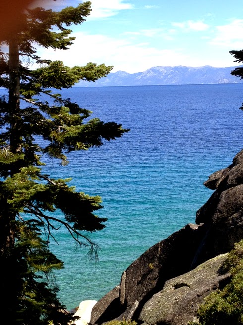
This is a view of the south beach from above. Rubicon Point is at the end of the beach.
This is the view of the south beach from down on the sand.

This is the north beach, right next to the closest parking lot. Wow.
What a great place to hole up with a novel. Is that Marlette Peak across the lake?
I can almost see the Flume Trail, which is featured in the book I'm reading, Tahoe Killshot.