Showing posts with label Tahoe Science. Show all posts

Sunday, January 16, 2022

Bald Eagles Soar (And Indicate Environmental Health)

 Back when the Bald Eagle was chosen as our national symbol (Ben Franklin wanted it to be the wild turkey), they were nearly everywhere in the country. 


Bald Eagles always stood out as huge, majestic, gorgeous birds, (up to 14 pounds and an 8-foot wingspan) who patrolled our waterways looking for fish to eat. (Never mind for the moment that one of the eagle's main approaches to obtaining food was to steal it from Ospreys after they'd done the hard work of catching the fish!)

When DDT was first invented in the late 19th century, it became a popular insecticide. As is typical, no one paid much attention at first to potential side effects. Unfortunately, DDT was responsible for decimating bird populations. Bald Eagles were among many species that nearly went extinct. (Not to mention that mosquitos had developed significant resistance to the poison!)

After much argument and hostility toward environmentalists, DDT was eventually banned in 1972. (Why is it always so hard to protect the environment?)

By the time DDT was banned, Bald Eagles had been killed in such great numbers, their survival was touch-and-go.

The first time anyone paid attention to Bald Eagles in the Tahoe Basin, there were only a couple of them.

Fast forward several decades and their numbers began climbing. In 2017, the Tahoe raptor count showed 27 Bald Eagles. In 2021, 42 Bald Eagles! 

Our beautfiful national bird is back. Everyone who spends much time hiking in Tahoe has seen them. 

Hurrah for the eagles!


Sunday, May 30, 2021

This Earthquake Stuff Is Getting Routine


I was at my computer when the most recent quake hit, two days ago. It was, for us, a whole lotta shakin' goin' on. People who reside near major fault lines would probably scoff at our reaction, considering no building fell down, no tsunamis washed up on shore, no pipelines were severed by shifting land.

The quake was a mile or so below the center of Lake Tahoe. It was close to the location of one of the last significant quakes. Hmmm. Are the Earthquake gods trying to tell us something?


Sunday, February 21, 2021

Quiz - Lake Tahoe Volume Compared To Other Lakes

 If you look at lakes on the map of the United States, you'll see five big ones stand out. The five Great Lakes are big by any measure.  Lakes Superior, Michigan, Huron, Ontario, and Erie. In addition to surface area, those are the five biggest U.S. lakes by volume as well.

So what lake comes in at number six by volume? A glance at the map shows dozens of possibilities. You know the answer of course, because you're reading my blog.


Lake Tahoe isn't huge by surface area. But it is DEEP, the 10th deepest freshwater lake in the world. And it is the second highest big lake in the world.

As for volume, Tahoe contains 36 cubic miles of water. Nothing compared to Superior. But it's kind of amazing to look at the U.S. map and realize that after the five Great Lakes, Tahoe has more water than any other lake in the U.S.! 


Sunday, November 8, 2020

First Storm, Heavy Snow


By the end of today, the weather forecast has us receiving up to 13 inches of snow. Am I so glad because it begins the accumulation of our snow pack? Or because it eliminates our fire danger? Or is it simply that it distracts from the ongoing political circus in Washington??!!...


Sunday, September 8, 2019

Atmospheric Science And The Brilliance Of My Readers

Back in 2013, I wrote a blog about why it's usually colder in the mountains than in the valleys.
http://toddborg.blogspot.com/2013/01/why-are-mountains-colder-than-valleys.html
My focus, as I recall, was on the rate at which air cools as you gain elevation (roughly 4 degrees for every 1000 feet of altitude gain.)

I got some things right, but I got some major points wrong. Six years later, a reader I haven't met, Neal Mielke, wrote a response to that blog. He was gracious in his corrections, and I appreciated his input very much.

Neal's smarts are self-evident. After I wrote him back, I found out what I suspected - that he was a Physics major back in the day. (It must grate on fellows like Neal when a physics dilettante like me rambles on without expertise). So I print his response here.

Thanks again, Neal.

Here is his letter:

Hi Todd,
 
I just discovered your mystery novels, and your blogs, and I am enjoying both.  I’d like to comment on your 2013 blog about “why mountains are colder than valleys.”  OK, it’s an old blog, and I’m years late in making a comment.  But I just bought your 5th novel, and that’s even older, so hopefully you’ll forgive me. 
 
You wrote: “The simple only-kind-of-techy answer is that the lower you are the more atmosphere is above you, and the more the air gets squeezed by all the air above it. The molecules in compressed air have more energy and they bounce around faster than they do in air that isn't so compressed.”
 
Pressure being the root cause just isn’t right, and thinking that it is will lead a person to be confused about a lot of situations where higher pressure doesn’t correlate at all with higher temperature.  The air in a scuba tank isn’t hot, even though its pressure is more than 100 atmospheres.  There are also a bunch of real-world meteorological effects that would make no sense if higher pressure led to higher temperature:
 
1) Christmas Valley was colder than Echo Summit last night, even though Christmas Valley is lower
2) Frost often forms on valley bottoms when the nearby hilltops are frost-free
3) Meteorologists often refer to inversion layers, when warm air is above cold air
4) An upstairs loft in a townhouse or condo can be baking when the bottom level is cold
5) Once one hits the stratosphere, air temperature starts to rise with increasing altitude
6) Water temperature drops as one dives further below the surface of water, while pressure dramatically increases.
 
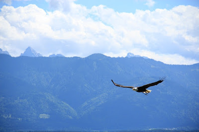
Thinking in terms of pressure also misses out on explaining why thunderheads form over mountains rather than valleys.  And why hawks (or a hanglider) circling overhead is a visual manifestation of the lapse-rate effect.  Understanding the reality behind the lapse rate is pretty cool, I think, and it’s worth really understanding it.
 
Localized heating combined with convective heat flow (warm air rising and cooling as it expands) is the real reason for all of this: the lapse rate effect that you blogged about, the seemingly contrary examples that I listed above, plus thunderheads and circling hawks.  If you want a simple non-techy answer to give people, it would be better to say “it gets colder as you go higher because you’re getting farther from the source of heat, which is the sun hitting and warming the Earth’s surface.”  The atmosphere is nearly transparent to the sun, which means that the sun warms the earth rather than the atmosphere directly.  The atmosphere gets warmed only indirectly, from contact with the surface.  When the surface air gets warmed it rises and carries heat higher into the atmosphere, so the whole atmosphere gets warmed.  You “see” that effect when you see hawks circling in a thermal – they’re riding the rising warm air.  The lapse rate of (about) 4 degrees per thousand feet exists because that’s the natural rate at which warm air rising cools as it expands.  That lapse rate can actually be calculated on a single sheet of paper, from a handful of equations including the Ideal Gas Law. 
 
  Think of the sun-baked earth (or surface of Tahoe) as a hot plate, and a lot of things will make sense.
 
Christmas Valley was colder than Echo Summit last night because the surface heating went away when the sun set – the hot plate got turned off.  Even more than that, the Earth’s surface radiates more infrared energy than the air does (otherwise night-vision goggles would see nothing but murky air).  So the surface cools faster than the air – the hot plate turns into a cold plate.  This cools the air in contact with the ground, and the cold air is stuck there because cold air wants to sink rather than rise.  Because of that there are no “reverse thermals” of warm air above flowing down to the ground.  The cold air clings to a narrow boundary layer close to the ground, trying to sink.  The cold air in Christmas Valley stayed there, and the cold air up on Echo Summit flowed down to join it.  That cold-air-flowing-downhill effect is the same reason why frost often forms on valley bottoms but not on hilltops.  And inversion layers happen because warm air rising is a one-way street.  If anything causes warm air to be above cold air, it’ll tend to stay that way.  Inversion layers are common in the morning, because of the cold-plate effect, and they can happen when a warm air mass moves sideways over a colder one.
 
Convection is also why upstairs lofts are hotter than rooms downstairs.  The warm air from the heat registers rises.  It wants to cool as it rises, but merely at 4 degrees per thousand feet, to that’s a negligible effect indoors.
 
Temperature starts rising with altitude once one reaches the stratosphere, because there’s actually a second hot plate up even higher.  That’s the ozone layer, which absorbs most of the sun’s UV energy.  Up there, the temperature rises with altitude because you’re getting closer to that source of heat.  It’s an inversion layer (higher temperatures at higher altitudes), so this is stable – the warmest air is generated way up high and it doesn’t want to sink.  Similarly, if you dive below the surface of the ocean (or Tahoe), it gets colder as you go deeper.  That’s because the heat source is above you where the sun hits the surface, and you’re getting farther away from it as you go deeper.  This too is an inversion layer.  Warmer water is less dense than colder water, so warmer water stays near the surface.  (This effect, famously, reverses near the freezing point, at which point colder water is actually less dense than slightly warmer water.  Everyone knows that ice floats, but water that’s very near freezing also floats to the top.)
 
What about those thunderheads?  Well, if you think about it, why should Tahoe be cooler than Sacramento, if sunlight is all that matters and pressure is irrelevant?  The sunlight at Tahoe is just as strong as in Sacramento.  Why doesn’t the surface of the Tahoe basin heat up to 100 degrees, the same as Sacramento?  Well, it would ... if you surrounded the Tahoe basin with a wall that extended up into the stratosphere (and made it transparent so that it didn’t block the sun).  But at 10,000 feet the temperature would be about 85 above Tahoe and 60 above Sacramento.  If the wall went poof, the warm Tahoe air would rise and the cold Sacramento air would rush in, because cold air is heavier than warm air.  This air movement would stop only when the temperature at 10,000 feet was the same in both places, which (because of the lapse rate) would mean that the temperature at Tahoe’s surface would be the same as above Sacramento at 6200 feet.  So, horizontal airflow guarantees that Tahoe is cooler than Sacramento.  There’s no wall going poof, so the effect is a gradual one, but it’s there, and it’s responsible for afternoon thunderheads.  The sun “tries” to heat the air at the summit of Mt. Tallac just as much as it’s heating the surface air in Sacramento.  But hot air at Tallac’s altitude doesn’t belong there – on all sides it’s surrounded by colder, denser air.  So when the sun is out there will always be a thermal rising from the summit of Mt. Tallac.  And if the humidity is right you’ll get a cloud forming above the peak.  Thunderheads form in the afternoons because the effect builds and builds as the day progresses, until the sun starts to set.
 
I hope that this is interesting to you, and not an annoyance.  Again, I’m enjoying your novels and your blogs.
 
Regards
 
Neal Mielke
(from the Bay Area ... love the Sierras though!)

Sunday, February 7, 2016

How To Prevent Attitude Sickness

In last week's post, I talked about altitude sickness and what to do if it strikes. This week, we look at the reasons why we get altitude sickness and how to prevent it.

The Earth's atmosphere is very thin. Compared to the size of our planet,
the atmosphere is as thin as the skin on an apple. You don't have to go
very high before you climb a substantial part of the way through that skin.

While nearly all of the Earth's atmosphere is below 100,000 feet, gravity compresses the atmosphere close to the Earth's surface. The air gets denser the closer you go to sea level. As a result, about half of all our planet's air is below 18,000 feet. 30% of the Earth's atmosphere is below 10,000 feet, and 20% is below 6000 feet. So just going from sea level up to 6000 feet, you have 20% less oxygen available to your lungs. Lake Tahoe, at 6230 feet, is higher than that. And all of the roads into the basin except one have passes over 7100 feet. The Mt. Rose highway crests at almost 9000 feet. It's very easy to get into territory with dramatically lowered oxygen levels. (Note that the percentage of oxygen in the atmosphere stays consistent at about 21%, but as the atmosphere thins, the oxygen "partial pressure" drops accordingly, and you get an equivalent drop in how much oxygen gets into your blood.)

If you're skiing at 10,000 feet and sleeping at 8000 feet (as in a Kirkwood vacation home), you are putting your body into a substantially hypoxic environment. Our bodies struggle when we don't have enough oxygen. The struggle can be very stressful.

If you want to acclimate without stress, what should you do?

A huge help is to spend a night at altitude before you start skiing or riding. Twenty-four hours without physical effort is even better. Staying in a lodging near 6500 feet (close to lake level) instead of one at 7500 feet also helps.

Where are the highest lodgings in the Tahoe area? The town of Kirkwood sits at 7800 feet, which is where you'll find most of its lodgings. But some of its homes - available on vacation rental websites - sit substantially higher. Many vacation homes on upper Kingsbury Grade - some near Heavenly's Stagecoach and Boulder access points - are also around 7800 feet. There are also vacation homes up above Incline Village that are at the same altitude. Don't avoid these wonderful places to stay, but consider allowing an extra day at that altitude before your first day of skiing.

At the minimum, try to get a night's sleep at altitude before hitting the slopes. You will find life at altitude much more comfortable.

How long does it take to fully acclimate?

It's been estimated that those of us who live at 6500 feet eventually produce extra blood (perhaps a pint or more) and we possibly develop the ability to carry more oxygen in our hemoglobin. How long does this adaptation take? Some estimates suggest one month. Anecdotally, many of us will attest to the fact that when we first came to Tahoe, we got out of breath just brushing our teeth. But after one month, life was back to normal.

What happens if Tahoe locals go down to sea level? We immediately start losing those adaptations. If we spend a month or more at sea level, we have to re-acclimate all over again when we come back up to Tahoe.

Bottom line? If you want to prevent altitude sickness, go slowly. Stay near the lake level, especially during your first day. Sleep overnight before doing lots of exercise. If you're planning on riding multiple areas, start with areas at lower elevation, such as Homewood. Or the lower slopes at Squaw Valley. As the days progress, move to the other areas, saving the highest areas, Mr. Rose, Heavenly, and Kirkwood for last.

These simple steps will give you a great winter vacation!

P.S. People who've lived for thousands of years in the highest areas of the world, like Tibet, the Andes, and the Ethiopian highlands, have evolved several different adaptations including genetic differences that allow them to better absorb oxygen at high altitude. So don't think, "Hey, sherpas can hang out at 16,000 feet, so I can too...!"

P.P.S. If you want to see dramatic evidence of the effects of thin atmosphere on living things, just look at the WhiteBark Pines at the top of Sky Chair at Heavenly (10,000 feet above sea level). Talk about scrawny plants desperately trying to eek out a living where the air is so thin.

These Whitebark Pines are old but no taller than the skier who's using them for slalom poles.
Photo courtesy of Skiheavenly.com


Sunday, January 31, 2016

Who Can Suffer From High Altitude Sickness?

The short answer: Anyone.


You wedge an opening in your schedule to make a ski getaway and come to Tahoe, leaving the Bay Area or Sacramento early in the morning. The slopes have awesome snow, and you hit them hard that first day, maybe a bit too hard. That night, as you are about to fall into the sack, you start to feel sick and you wonder if it was your over-exertion or your celebratory beer or wine.

Probably, it was neither. It was altitude.

Altitude sickness can hit anyone, even people in very good shape. Typically, it strikes when you live near sea level and go up to 8000 feet or more. While most of the lodgings in Tahoe are below 7500 feet, much of the skiing and boarding is above 8000 feet. For example, if you go Heavenly, Tahoe's highest area, and ride the upper mountain on either the California or Nevada side, you will spend much of your day above 9000 feet. At Kirkwood or Mt. Rose, it's also possible to spend much of your day above 9000 feet.

A body has a strong reaction to being deprived of oxygen. The reaction can even be dangerous. Altitude sickness will initially manifest as a major headache. I don't want to scare you, but if it progresses to nausea and vomiting, you may be at risk for pulmonary edema or cerebral edema. It's time to get down to lower altitude fast! Seriously. Otherwise, you could suffer a cascade of events that lead to coma and death. A drop of 2000 feet or more will make a big difference. If altitude sickness strikes in Tahoe, taking an hour to drive down to Reno or Carson City (both around 4500 feet) can make you feel much better and can even save your life. Even if you only go down for a few hours, it can revitalize your brain and body. (Of course, if you are really sick, seek medical attention.)

Why does does altitude sickness happen and how can you prevent it? Tune in next week...


Sunday, January 4, 2015

Why Is The Full Moon Higher In Winter Than In Summer?

Tonight, January 4th, the moon is full. Yea! 

At 8:53 p.m. on the West Coast, to be exact. (On calendars, it says the full moon is January 5th, but that's because the official date of the full moon is based on the time in Greenwich Mean Time, otherwise known as UTC - Coordinated Universal Time.) And when it is 8:53 p.m. on the West Coast, it is 4:53 a.m. the next day in London. Which explains why we often look up at the moon on the "calendar date" of the full moon and think, "I think it was fuller last night." Because, for us, the full moon was the night before.

In Tahoe, we often notice the full moon because:
1) Our nights have less light pollution, so the moon is brighter
2) We're at high altitude, so there is less atmosphere above us to dim the moon
3) The snow on the mountains is spectacular in the moonlight, begging us to notice


This is from a cool website called MoonGiant.com


If you notice full moons, you can't help wondering why the full moons of winter are way, way up high in the sky, making it so bright on the snow that you can easily read by moonlight. By comparison, summer full moons are low in the sky.

Ever notice how the full moon track is just like the sun's track, only the summer and winter tracks are reversed?

I wondered why that is, so I looked it up.

It turns out that it has to do with the fact that the Earth is tilted on its axis (which is what gives us our seasons among other cool stuff). And when the moon revolves around the Earth, it doesn't stay over the Earth's equator, it stays on the same plane as the Earth's orbit and the sun and most of the planets. 

That plane is called the ecliptic, and all the stuff that stays on the ecliptic plane got that way because when the solar system first began to coalesce, the material that eventually became the planets contracted into a spinning disc. The spin and plane of that disc has stayed the same ever since.

Here's an easy way to visualize why the full moons are higher in winter than summer. 

First, remember that when the Moon is full, it is on the opposite side of the Earth from the sun, so its entire surface that we see is illuminated.

Now think of a globe sitting on a really large table. The table represents the ecliptic, and most of the stuff in the solar system stays on that table. As you know, a globe accurately depicts the Earth at a tilt. The Earth, like the most of the solar system's inhabitants, also stays on the ecliptic plane as it orbits the sun. It just stays tilted as it moves around. 

When the Earth's North Pole is pointing toward the sun, it makes for the long days of summer for those of us in the northern hemisphere. But when the Earth rotates so that we are in the dark of night and we look up to see the full moon, it is on the opposite side of the Earth from the sun. So when the sun is high in the summer, that means that the moon is low.

In winter, the opposite is true. The Earth's North Pole points away from the sun, so the sun is low in the sky. The full moon, on the opposite side of the Earth from the sun, is now high in the sky.

So enjoy the glorious full moon tonight. Along with the full moon we had in December, tonight's full moon will be higher in the sky than any other until next December. And with the snow on the mountains, Tahoe's full moon is a real treat!

Sunday, December 28, 2014

How Much Longer Does Each Day Get Over The Course Of Winter?

Tahoe is at 39 degrees of latitude, so our winter days aren’t nearly as short as in places farther north like Seattle or Minneapolis or “the Portlands,” either Oregon or Maine. Even so, I love longer daylight, and I wait for the days to start stretching out again after the Winter Solstice, the shortest day of the year. But how much is the increase in daylight every day?


The answer would seem to be easy to calculate. One could take the difference in day length between the Winter Solstice (Dec 21st) and the Summer Solstice (June 21st) and divide by the number of days in that period (about 182).


In Tahoe, our shortest day is about 9 hours and 28 minutes. Come the Summer Solstice, our longest day is about 14 hours and 52 minutes. If you divide the difference (5 hours and 24 minutes) by 182 days, you’d think that our day length increases by about 1 minute and 46 seconds each day.


But that isn’t the case! In fact, the amount of the day length increase changes dramatically depending on the time of the year. For example, in the days right after the Winter Solstice, the day length increases by only a few seconds with each passing day. But come the Vernal Equinox (Mar 21st), the day length increases by 2 minutes and 31 seconds with each passing day. Why the disparity?

I did a little research, and here’s what I learned.

To help illustrate why, visualize a clockface.


Pardon my scratchy, hard-to-read printing!
(You can see why my wife is the artist in the family!)

The Earth is tilted about 23 degrees. In December, when the Northern Hemisphere tilts away from the sun, we get a shorter day. In June, the opposite is true. The Northern Hemisphere tilts toward the sun, and we get a longer day.

As the Earth moves, it travels counter-clockwise when viewed from above. The closer the Earth is to the bottom of this sketch, the shorter the day in the Northern Hemisphere. In contrast, the closer the Earth is to the top of the sketch, the longer day.

But consider this. As the Earth moves from December 21st to January 21st, it's mostly just moved to the right on the sketch. It's gone very little toward the top. So the day length has increased just a smidgen in an entire month. 

But when the Earth gets to the part of its orbit from mid-February to mid-April, a month's worth of movement takes it much farther toward the top of its orbit, thus increasing the day length a lot!

Here's an example of what a difference that makes. In the ten days after the Winter Solstice, the total day length increase is only 2.5 minutes. But in the ten days after the Equinox, the day length increases about 25 minutes. Ten times as much! As represented on the sketch, that's because the Earth has moved ten times as much toward the place where we have the Summer Solstice.

So the next time you wonder how much day length increases or decreases, remember that it's completely dependent on the time of the year. At the Equinoxes, day length changes a lot every day. At the Solstices, day length barely budges.

Whew! Glad we figured that out, huh?!

P.S. I always wait for Owen McKenna's Ten/Ten Rule Of Sunlight to kick in on January 21st. Here's a blog about that.

Sunday, November 30, 2014

The Wild Daily Temperature Swings Of Tahoe

A friend in Portland told me that he has often noticed that the weather report for Tahoe shows large temperature differences between the daily highs and the nighttime lows. I've noticed it too, but I never really paid attention to it. For those of us in Tahoe, we just love the way summer nights cool down into the upper 30s even when the daytime highs sometimes get into the upper 80s. The winter swings are not so dramatic, but they are still significant.

With the fall nights getting down into the teens, I was reminded of my friend's comment. Here's a screen shot of the National Weather Service website from last month. Three days in a row, we had a 50-degree temperature variation from high to low.


The question is, why do some places (like Tahoe) have such large temperature swings and others (like Portland) do not?

So I did some research. What I learned is that it's all about humidity. 

Water vapor is a Greenhouse gas. Which means, it keeps heat it by letting sun rays pass through during the day to warm up the earth. Then at night, when the earth is radiating its heat back into space in the form of infrared radiation (a substantially different wavelength than much of sunlight), water vapor bounces that radiation back to earth. So water vapor is relatively transparent to much of sunlight but relatively opaque to infrared radiation.

The bottom line is that moist climates don't lose anywhere near as much heat during the night. Dry climates like deserts lose a great deal of heat during the night because there is almost no water vapor in the atmosphere to bounce that infrared radiation back to earth where it came from.

You may be thinking, "But Tahoe isn't a desert." It's true that most years Tahoe gets a lot of precipitation, mostly in the form of snow. But what's interesting is that Tahoe's precipitation comes in storms, or waves of storms off the Pacific. We rarely get moist air masses that just hang out and drizzle on us. Our storms come in fast and move out in a day or two. During those times, we have high humidity and thus we have small daily temperature swings. 

But when we don't have storms, we get the same dry climate as the high deserts of Western Nevada.

It's a great climate. We get storms maybe once a week during the winter, and the rest of the time, summer and winter, we have dry air which brings us our amazing sunshine.

It also brings us wild daily temperature swings, warm sunny days with cool nights.

Those of us who live here think it's perfect.

Sunday, January 26, 2014

Owen McKenna's Ten/Ten Rule Of Sunlight

In Tahoe, as with everywhere else in the northern hemisphere, the two darkest months are over.
Like Owen McKenna, I don't like long winter nights. Yes, sitting in front of the fire, reading a good mystery while sipping a glass of wine is great experience on a cold, dark night, and winter gives us that. But I like sunshine, and I like it to be light at least through the entire afternoon.
In Tahoe, the days during the month before and the month after the Winter Solstice (December 21st) each have less than ten hours of daylight. Not good for me. So I'm unhappy to see the approach of November 21st. This last week, exactly two months later, I was relieved to see the sun climbing back into the sky. The sun is once again high enough that we can now enjoy ten months of days that are longer than ten hours.
Welcome to Owen McKenna's Ten/Ten Rule Of Sunlight.  
The 21st day in January is when Tahoe's daylight is once again ten hours
long or longer. It will remain that way until November 21st.
There are multiple websites that allow you to calculate your day length for any latitude and for any day of the year. One I like is timeanddate.com. Here is the link for Sacramento.  You search by finding the closest major city to you that is a similar latitude, i.e. on a north-south basis. You can pick your month. It will give you sunrise and sunset times, day length, and the altitude in degrees of the sun at noon. (Note that the third hit on my Google search -solartopo.com - had wildly inaccurate sunset times for Sacramento - an obvious mistake - so like anything on the internet, you can't always assume accuracy.)
It's fun (really!) to compare day lengths and sun angles for cities farther north or farther south. For example, our friends in Seattle find the sun 9 degrees lower in the sky than we do. And during the last week of January, their day length is still 50 minutes shorter. Ouch! But come the Summer Solstice (June 21st) their day length will be over an hour longer than ours.
You can also see how the amount of change in day length increases as we get closer to the spring and fall equinoxes and decreases as we get closer to the summer and winter solstices.
The bottom line is that Tahoe is south enough to get good winter sun but north enough and high enough to not bake in the summer.
For sun lovers, Tahoe is one of the great climates.

Compared to the more than half of the USA that is north of us,
Tahoe has great, high winter sun.

Sunday, November 3, 2013

How To Change Your Weather

For those of us who live in the mountains, there's a variation on the weather jokes. Don't like your weather? Go up or down a thousand feet.
On a quick road trip up I-5 to Seattle last week, I noticed that the snow on Mt. Shasta came down to approximately 7000 feet of elevation.
Mt. Shasta in Northern California

 Farther north, I noticed that the snow on Mt. Hood came down to approximately 6000 feet.
Mt. Hood in Northern Oregon
We expect this, of course, because it gets colder as you go north.
If instead of going north, we'd gone south the same distance from Shasta we could have been to Mt. Whitney. There, the lowest snow level would have probably been around 8000 feet.
So I wondered if there is a regular relationship between where you are on a north/south basis and where you are on an elevation basis. After a little research, I found out that there is, and it matches what I noticed on the way to Seattle.
All other things being equal, going 300 miles north changes your climate approximately the same as going up 1000 feet in elevation.
Of course, in most scenarios, all other things are not equal. If you go farther from or closer to the Pacific Ocean, which is a huge modifier of climate, that will change things as much or more than anything else.
But it is still an interesting comparison. Going 3000 miles north is like going up 10,000 feet. So if I were to start in Sacramento, which is near sea level, and go to the northernmost reaches of the Canadian arctic (3000 miles), my temperature change in any given season would be similar to going from Sacramento to the top of Heavenly ski resort at 10,000 feet.
Useful information?
Maybe not. But fun!


Sunday, July 14, 2013

A Possible Reason That Tahoe Doesn't Have Rattlesnakes

A few weeks ago, I wondered if there were rattlesnakes in Tahoe. (See post here.) The answer appears to be either no or very few. (No one has reported to me a sighting in the basin.) It's an interesting question because there are rattlesnakes at equivalent elevations elsewhere in the Sierra.
Recently, wildlife expert and photographer Jim Stamates wrote me an addendum to the subject. Here's what he said.
Another thought; perhaps the snakes were killed by the early settlers to the basin. They cut down all the trees, killed all the deer for miner's food, commercially fished all the Lahontan Cutthroat trout, why not snakes? Their comeback would be harder than most, as you mentioned, trying to get over the summits.”

It makes sense and is the best explanation yet of why we don't have rattlesnakes. Back in the 19th century, our forebears did a pretty good job of trashing Tahoe as they cut nearly all the forests down to provide the supporting timbers for uncountable miles of mining tunnels beneath Virginia City.
Although several notable voices of wilderness preservation rose and became part of the fabric of discussion about Tahoe (think John Muir, the Sierra Club, The League To Save Lake Tahoe, etc.), Tahoe developers in the mid-20th century continued the trashing with an embarrassing gusto, filling in wetlands, dredging canals, and building roads and putting up buildings without regard to runoff and other impacts on the area.
Perhaps more than any other single person, John Muir is responsible for getting us all to think about preserving nature. Because of Muir, we began to realize that the best use of land is not always plowing it up or covering it with buildings and pavement. 
Some of the worst results of our impact on nature have been mitigated to some degree by changes in policy. One possible impact – eliminating rattlesnakes from the basin – hasn't been documented or mitigated to my knowledge. (Anyone out there for reintroducing rattlesnakes to our paradise???)
Unlike other efforts to bring Tahoe back to an ecosystem closer to that of 100 years ago with regard to fish and beaver and a range of other creatures, the poor rattlesnake doesn't seem to have a lot of supporters, patrons, and cheerleaders.
Sorry, all you herpetologists. For now at least, when I'm out hiking, I'll keep picking up interesting rocks and other objects without wondering what surprise may lie underneath.


Sunday, June 16, 2013

Are There Rattlesnakes In Tahoe?

The high-altitude living of Tahoe offers many benefits if you like to spend time outdoors. Perfect summer weather. Dry enough in the summer to prevent nearly all bugs from taking up residence. Nights that are cold enough to stop the few remaining pesky bugs in their flight paths. Hot sunshine on even the coldest winter days. A high proportion of sunny days. And glorious recreation including uncountable spectacular hiking trails.
But what about rattlesnakes on those trails?
Some time back, we were hiking a couple of hundred miles north of - and 4000 feet lower than - Tahoe, when we came upon a rattler. We later identified it by his beautiful pattern as a Pacific Coast Rattlesnake. He lay coiled on the trail, his head up in the air, his tail up, too, but held a little lower.
He wasn't shaking his rattle. We hadn't gotten close enough for him to go into alarm mode. But he was aware of us. Very aware. Except for the snaking, serpent tongue – stuff of legends and bad dreams alike – he was still. We watched and we stayed as still as possible. But not like this guy. He could do still better than your average rock.
In the end, he won the staring contest. We gave him wide berth and went on our way. For the rest of our hiking trip, every step took on a new weight. We weren't just exploring the Northern California wilderness, we were running the timeless gauntlet, man against nature. And the serpents were out there, ready to take us down.
How can you prepare against something that might slither right up your pant leg? (It would probably never happen, but I'm a writer. My job is to imagine, right?) Add in curved, needle teeth and you can barely stand to visualize what body part into which that guy might decide to inject his venom.
All of which made us glad to come back to Tahoe because, to our knowledge, we don't have rattlesnakes anywhere in the Tahoe Basin.
But is that really true? There are several varieties of rattlesnake to be found throughout the foothills to the west. And to the east of Lake Tahoe – Carson Valley, Washoe Valley and Reno's Truckee Meadows – there are a good supply of legless reptiles with very sharp venom-delivery tools.
A little Google research will turn up a few fish-and-wildlife officials who say snakes could be in Tahoe. But none of them definitively say that rattlesnakes live in the basin. I did find one credible personal account of hikers encountering a rattlesnake near Margaret Lake, which is near Kirkwood but out of the Tahoe Basin.  Margaret Lake is at 7000 feet and, like Kirkwood, it gets a ton of snow, and the territory is similar to Tahoe, so it makes you think...  
It seems as if we should have lots of snakes in Tahoe. On our warmest days, the gophers and other small rodents are numerous enough to feed an army of snakes. Certainly, they feed an army of coyotes.
But even if we allow for the possibility of rattlesnakes in the basin, the fact is that few-to-no sightings means there are very, very few, if any. 
No one posits any thoughtful explanation of why this should be. Maybe our weather is just too cool for too long. Maybe we have enough aggressive hawks and eagles to make it impossible for any snakes to ply their trade here. Death from the sky is a snake's worst nightmare. Any snakes thinking of slithering over one of the passes into the basin might decide that it's too much work only to have to make a return trip before the snow comes back in the fall. 


I asked him if he'd ever seen a rattlesnake in Tahoe, and he said he hadn't. So I asked him, "If Great Basin Rattlesnakes can be found up to ten thousand feet, why don't we have rattlers on our hiking trails?" He said, "Too many tourists?"
If Jim is right, then book your trip to Tahoe now! We need you to keep the rattlers away.

Here is a Great Basin Rattlesnake that Jim photographed on Anaho Island on Pyramid Lake.(Tahoe's water flows down the Truckee River to Reno and then on to Pyramid Lake. Pyramid Lake has no outlet. Its water simply evaporates over time.)


So snake lovers beware. Tahoe ain't your territory. We have lots of bear and coyote. And there have been two mountain lion sightings on the South Shore this year. But there is a disappointing, depressing, deficiency of rattlesnakes in these mountains. Sad as that is, so far we're coping just fine!

Sunday, April 7, 2013

Beauty Follows Science, or Sailing On Lake Tahoe is Another Kind Of Wind Power


I often watch the sailing regattas on Lake Tahoe and admire the beauty of airfoils designed to extract power from the wind.


A few weeks ago, I saw a second cousin to those gorgeous sailboats.
I was driving through the Mojave Desert when I overtook a slow-moving truck with a flashing sign that said “Oversized load.”
Wow, talk about understatement. You know those logging trucks where the cab is connected to the rear wheels not by a truck structure but by the logs themselves? This truck was like that, except it seemed like it was maybe 200 feet long.
I slowed as I moved into the left lane to go past.
What I saw was a fantastic, beautiful, monstrous curve of white. It may have been made of fiberglass or titanium or some other techy material. I couldn't tell. It curved in all three dimensions and brought back hazy memories of reading about hyperbolic paraboloids from science texts back in college.
I thought it was the largest – and one of the most beautiful – abstract sculptures I'd ever seen. Then I realized what I was looking at.
It was a single blade for a monster wind turbine.

I slowed my car, matched speeds with the truck, and stared at this wing that was much longer than those on a 747 jet and, with its complicated multiple curves, probably more complicated in design. It was like an America's Cup sailboat-meets-Mars-mission technology.
Up close, it was one of the coolest things I'd ever seen, a beautiful shape that was designed to extract power from the wind. It was beautiful because the the science behind its design made it that way.

It is humbling to realize that the science of function is integral to many things of beauty. When I look at the spectacular sails of the boats out on Lake Tahoe, I realize that their beauty comes from a design that is all about function. 
WoodWind II Sailing Cruises on Tahoe

After seeing that huge turbine blade, I can never again look at the spinning blades of wind turbines without seeing them like sailboats. These are sails that turn. They take the invisible wind and turn it into electricity. A wind farm with many turbines is like a regatta with many racing boats. Instead of producing an afternoon thrill ride on the water, the turbines power our lights and appliances.
Beauty follows science.


Sunday, March 24, 2013

Wait, How Big Is Tahoe? 29 Years!


You've all heard the statistics about Lake Tahoe. They're on the back of restaurant menus, on calendars, in the wikipedia articles, on the travel websites. Length (22 miles), width (12 miles), depth (1635 feet), total water volume (150 cubic kilometers).
Tahoe From Space

Okay, it's a big lake. But how big is it in terms that we can understand?
Here's a statistic you've never heard.
I decided to run a few numbers. I wanted to know this: If every person on earth drank eight glasses of water a day and they dipped it out of Lake Tahoe, how long would the lake provide everyone on the planet with drinking water? A day? Several days? A few weeks?
We've got a bit over 7 billion people on this planet. That's a number too big to really grasp. Line up 7 billion 5-foot, 6-inch people and they'd stretch around the earth 291 times. Put all of us head to toe and we'd go to the moon 30 times. That's a lot of people. So if we're all drinking our recommended intake from the lake, how long would it last us?
Over 29 years.*
That's a lot of water from one mountain lake.
So the next time you drink a glass of water, invite everyone else on the planet to join you. Let's everybody do it eight times a day for 29 years.
Live large. It's Lake Tahoe.


*For those of you who want to do the math, there are a bit more than 4 eight-ounce glasses in a liter, a thousand liters in a cubic meter, a billion cubic meters in a cubic kilometer, and 150 cubic kilometers in Lake Tahoe. Divide by 7 billion people, then divide by 8 glasses a day, then divide by 365 days in a year, and you get 29 years. That's a lot of water.

Sunday, March 3, 2013

Tahoe's Clarity Is Improving!


 The UC Davis scientists who study this stuff dangle the Secchi disk (basically a white dinner plate or a black-and-white plate) down off the shady side of a boat at mid-day. They lower it until they can no longer see it, at which point they note the depth. After they start pulling it back up, they again note the depth when the plate reappears. Often the two figures vary a bit, so they average them. And just to make sure that they are getting reliable data, they do this measurement many times during the course of a year.
The average for 2012 was 75 feet. The lake hasn't been that clear since 2002.
UC Davis's John Le Conte research vessel
Before we get too excited and smug, it is good to remember that when they started taking these measurements in 1968, that little Secchi disk could be seen 102 feet down!
While this improving trend is great, the reasons why it is happening are less clear. At this point, the best guess is that the main mitigation has come from all of the infiltration ponds that have been built to catch and filter runoff water from streets as well as rebuilding creeks that once had meandering paths and flood zones but were dredged and straightened by developers in years past.
There is lots more to do. There is still a scary number of drainage pipes that dump dirty storm runoff water directly into the lake. These have been documented by the Tahoe Pipe Club.

There are infestations of non-native mussels and fish that lead to algae blooms. There are massive ongoing erosion areas from old road cuts such as Meyer's Grade.
And there are other problems that might be even harder to tackle, such as the nutrient load from dust and dirt that blows in from the Central Valley, especially when the farmers are plowing or burning slash. Scientists have even identified silt that has blown into the lake from China's and Mongolia's Gobi Desert after a dust storm half a world away.
But for now, we are glad that the lake is improving, and we salute those individuals and groups that made it possible!

Sunday, January 6, 2013

Why Are Mountains Colder Than Valleys?


We've all noticed that when you drive from the valley up into the mountains it cools off. (Which is why Tahoe is so popular in August when it hits triple digits in Sacramento.)
Why is this?
The simple only-kind-of-techy answer is that the lower you are the more atmosphere is above you, and the more the air gets squeezed by all the air above it. The molecules in compressed air have more energy and they bounce around faster than they do in air that isn't so compressed.
Lucky for us, we have sensors in our skin that can take a reading on how fast those molecules are hitting us. We call it temperature. It's a self-protective measure, because if those molecules hit us too fast, we cook. And if they hit us too slow, we freeze.
(From the Orange County Register)

Okay, that's simplified.
What I really wanted to know is this: Is there a regular amount that temperature rises or falls when you go down the mountain or up the mountain?
So I did a little Wikipedia research.
First thing I noticed was that this is a regular subject (Who knew?), and it's called the Temperature Lapse Rate.
Turns out that the answer is yes, the temp fluctuates with elevation change in a regular manner. How much?
Well, as always there is a complication or two, and they involve how humid the air is and how much it is moving. But I learned that there is a range that we can count on.
If the air is really dry, the temps will cool a bit over 5 degrees Fahrenheit for each thousand feet you go up.
And if the air is really humid, the temps will cool a bit less than 3 degrees for each thousand feet you go up.
I had to pause at that point and think about the air around Tahoe. Usually it is quite dry except when we get storms. So I decided there was nothing wrong with taking an average.
Average "less-than-3" with "more-than-5" and you get a nice round 4.
So there's my answer. On average, the temp goes up or down about 4 degrees for every thousand feet of elevation loss or gain.
Let's say I'm at Donner Summit, a bit over 7000 feet above sea level. It's January 6th, and the temperature is a chilly 25 degrees. What's the temp in the Central Valley? Because the Central Valley is close to sea level, I'll lose approximately 7000 feet. 7 (for seven thousand feet) times 4 degrees equals 28 degrees. So Sacramento is probably a comfortable 53 degrees (28 plus 25).
Play the game in reverse: How much can a broiling Sacto resident expect to cool off when it is 105 degrees downtown in August? This time, let's ignore the summit, because most people don't vacation on the pass. They head on in to Tahoe at 6300 feet. Again, rounding, 6 (for six thousand feet) times 4 degrees is 24 degrees. So when Sac is 105, Tahoe is going to be 24 degrees cooler, or a pleasant 81.

Of course, the cold lake cools things off more, so we're probably more like 77 degrees.
Now we know why Tahoe gets crowded in the summer!

Sunday, September 9, 2012

Have Lunch on the Beach, See the Earth Curve!

Not every day do you get an amazing science lesson during lunch.
Most days, I eat lunch at the computer, or I take a sandwich in the car to eat while driving errands. Then come the glorious exceptions. A cooler on the beach. My wife next to me. 
Some time back, the sun was hot, the air cool and clear. We found a beach log to sit on just ten feet from the lapping waves. Turkey sandwiches, chips, apples, perfection. Okay, I forgot cookies, so it wasn't perfect. But close. The water was indigo, and the mountains – Mt. Tallac especially – still had some small snowfields in the high bowls to the side of The Cross.
The cerulean sky was decorated with jet contrails from travelers who probably looked down and thought, “Oh, my God, look at that view! Why are we flying someplace else when we could have gone to Tahoe?!”
Our postprandial activity was sailboat watching through binoculars. There were a variety of boats transforming wind into movement and play. The most interesting one was across the lake about 10 or 12 miles, over by Cave Rock, just a flicker to the naked eye, but easy to watch in the binoculars. It had a tall mast and a beautiful sail curved into a graceful, power-generating airfoil shape.
But what made it striking in looks was that the sail had no boat.
WHAT? NO BOAT?!
That's what we saw. A sail going back and forth with no hull below.
That's how much the earth curves.
Tahoe as seen from SR-71 Blackbird from approximately 90,000 feet
Photo credit F-16.net

It was fascinating to watch, this mast and sail dancing the waves sans boat.
Back home, I did some research. 
The simplest thing to say about the earth's shape is that it curves about 8 inches per mile. It would seem, then, that a 6-foot-tall person could see the water's surface about 9 miles away (6 feet = 72 inches. Divide by 8 inches – the amount of curve per mile – and you get 9 miles.)
Unfortunately, I learned that it ain't that simple.
The first complication in assessing long distance curvature is that with each additional mile, the earth's surface is curving away from you at 
an ever-increasing angle. Because of this, a 6-foot-tall person can see the water's surface only about 3 miles away.

If you want some techy explanation, go here:

This ever-increasing characteristic makes a huge difference as the distances increase.
If you want to see the waterline 10 miles away, you'd have to be about 66 feet up in the air.
If you want to see the waterline 22 miles away (the length of Tahoe), you'd have to be about 300 feet up in the air.
Now comes the second main complication. Because of the cool, denser air near the cold water's surface, light curves toward that surface just like it curves when it is refracted through a lens. The amount of refraction varies with different temperatures and other climatic conditions, but it can be substantial.
The result of this refraction negating the effects of curvature is that if you stand on Tahoe's North Shore, you may be able to sometimes see the tall hotels of the South Shore. But sometimes you won't because they are technically “below the curve of the earth” as seen from the North Shore. Only when light from them bends are they visible.
Of course, there is always one more thing to keep in mind. The earth's curvature is only noticeable when you are right down on the water. Most of the land around Tahoe is substantially above the lake. If you are up the mountain slope just a few hundred feet – as many of us are most of the time – then nothing on the shore is “below the curve of the earth.”
So next time you picnic at the water's edge, sit down close to the water and watch the sailboats with binoculars. You may be in for a science display treat!
P.S. Remember to bring cookies.