Sunday, July 7, 2013

What The Heck Is Flash Fiction? Can You Really Tell A Complete Story In 100 Words?

One day, Will had us try what sounded to me like a very difficult exercise. He wanted us to write a story in 100 words. The goal was to have the same basic structure of a novel. Open with a character in serious trouble (the hook), create a rising plot curve that led to a climax, and have a short resolution (the denouement).
I fumbled many times, only to find out that by the time I had a bit of a beginning, I was already at 175 words. To begin a story and carry it through a climax and a resolution and do it all in 100 words seemed impossible.
This experience reinforced what all of us learn when we try writing in various forms and lengths. The shorter the piece of writing, the harder it is.
Enter Flash Fiction, the new moniker that describes Will's writing assignment from 30 years ago. Not only are such stories fun to read, they're becoming popular.
My friend Mark Bacon has been writing Flash Fiction mysteries from his lair in Reno.

His latest book is Cops, Crooks & Other Stories in 100 Words: 101 Tales. Not only are the stories 100 words long, which is very difficult to do, but they are really fun! You can get the entire collection on your Kindle for only 99 cents.

I asked Mark some questions about it.

Q. You write stories that are 100 words long. You call it Flash Fiction. It's a great term. Where'd it come from?

Bacon: The term was coined in 1992 with the publication of Flash Fiction, 72 Very Short Stories. In the book’s introduction, James Thomas, one of the editors, says the term was created to differentiate under 750-word stories from longer stories published in two previous anthologies he edited.

The editors took their word length from a 1925 Hemingway story called A Very Short Story. It’s a good one about a World War I soldier and a nurse caring for him. It has a beginning, a middle and an end. You can find various versions of it online. One I read was just longer than 600 words

Was Hemingway’s tale the first flash fiction? Certainly not. If I had to guess, I’d say the first flash fiction author was Aesop in the sixth century BCE. Modern translations of the oral fable The Ant and the Grasshopper have it pegged at about 150 words.


Q. You taught journalism at Cal Poly and at UNR, you wrote for the San Francisco Chronicle for years, and your stories have appeared in a bunch of major, cool rags like The Washington Post. You've also written several non-fiction books. How'd you get from all that to Flash Fiction?

Bacon: It was all based on a dare from a friend who was using 100-word stories as a practice exercise for a writing group he was leading. He said I should try it. I wrote a couple of stories and enjoyed them. It was a great challenge to have a complete story with a satisfying ending in just 100-words. After the first few stories, I was hooked. I kept writing until I had more than enough for two short books.


Q. Is Flash Fiction changing the way you think?

Bacon: No, but reading on the Internet is, and not necessarily for the better. I believe our attention spans and our short-term memories are shrinking. For example, how long do you look at a website before you become impatient when you don’t see exactly what you’re seeking? Four to five seconds sound about right?

On the other hand, I think flash fiction is perfectly suited for impatient readers. My stories will get you to an ending--one I hope you didn’t see coming--in less than a minute.

Q. Do you get impatient when someone is talking and it takes them a bit to get to their point?

Bacon: Sometimes. I find that more the case in writing. My journalistic training taught me to put the most important information up front. Of course with mystery flash fiction, I save some of the good stuff 'til last.

Q. So, what is the accepted length for flash fiction? Is it 100 words, Hemingway’s 600 words, or something else?

Bacon: Good question but almost impossible to answer. Online flash fiction journals abound and there is a smattering of print anthologies as well, but editors have their own ideas of what constitutes flash fiction. Published flash fiction generally ranges from about 25 words to 1,500 words. The 100-word limit seems to be the most common.

Some writers even do 140-character stories to fit in a tweet. I’ve read some good ones and some not so good. I tried to cut down one of my stories to fit Twitter, but it took three or four tweets to really tell it completely.


Here's an example of Mark's Flash Fiction

----------------------------

Honor Among Thieves

The darkened home looked empty. Pete tried the front door. Locked. Around back, he jimmied open a patio door with a credit card.
Immediately, he saw a man holding a pillowcase full of something.
“Shit. You startled me,” the man said. “First time I ever seen two guys break into the same house. I came in the window. But hey, I believe in professional courtesy. I’ve got jewelry and laptops. Rest is yours.”
Pete opened a drawer, reached inside.
“Hold it,” Pete said, pointing a revolver.
“What about professional courtesy?”
“I forgot my keys,” Pete said. “I live here.”

Sunday, June 30, 2013

In Tahoe, The Whole Point Is Exercise

A friend was visiting from out of town. After a couple of days of exploring, we were driving up the switchbacks south of Emerald Bay, and the bicyclists racing up the steep inclines were ubiquitous. Our friend said, “It's like we're in Barbie and Ken Doll land. Everybody is so fit.”
Team Bicycle Trip .blogspot.com

It's true. Sometimes Tahoe feels like the place where people come to achieve physical perfection, or maybe just show it off.
Yet, I always notice what I call the Parking Lot/Exercise Paradox.
At the Tahoe supermarket, people drive around looking for the space closest to the door.
Worse, at Tahoe fitness clubs, people jockey for the parking spaces near the entrance. What?! I thought the whole point of going to the fitness center was to get exercise. In fact, for many, or even most, visitors, part of the point of coming to Tahoe is to get in shape.
Emerald Bay Physical Therapy


Of course, some might say that the lake and hiking trails and ski slopes are where the beauty is, not the parking lots. So they focus their fitness energies in those places. But exercise is good regardless of how we get it, right? 
Weekend Sherpa .com

Yet, in every parking lot, I can see mountains, some views of which are very beautiful. Well, actually, there are a few places where I can't see the mountains. And those are the parking places near the door.

Sunday, June 23, 2013

Tahoe's Shoe Index? Not Your Mother's High Heels

The day before the opening of the L.A. Times Book Festival on the campus of USC, I was setting up my books for exhibit. It was a quiet day with postcard-sunny SoCal weather, perfect for the young woman leading a tour group of prospective students and their parents. She stayed at the head of about 30 people, and she gave her entire monologue at high volume so that everyone could hear. It was an impressive performance that she repeated a couple of hours later with a second group. But what really caught my attention was that she did the entire campus circuit walking backward and wearing high heels. I was reminded of the line about how Ginger Rogers could dance every step as well as Fred Astaire, yet she did it backward and in high heels.
MindBodyGreen .com

When you watch such a performance, you can't help but wonder about the dichotomy between esthetic and function. Whatever one thinks about the merits of high heels, they are clearly a world away from the merits of foot gear designed for support and warmth and the ability to be worn for miles without producing blisters.
For a Tahoe local, that USC performance brought to mind the rarity of high heels in the Tahoe Basin. Such shoes no doubt exist in Tahoe. But outside of the casino showrooms, they are mostly hiding in the back of closets.

It made me wonder if there might be a useful shoe index that psychologists or sociologists could apply to locales and then cross-reference to people. People looking to find their ideal living environment could take a short self-assessment test regarding their shoe interests and then check it against a location's shoe index. It would save one a lot of wasted time moving to Tahoe for the beauty only to discover that your high-heel score of 9.5 is on the wrong end of the spectrum from Tahoe's high-heel index of 1. Likewise, the young person with a hiking boot score of 9 or 10 might realize that their unhappiness living in Manhattan can be solved simply by finding a region with hiking boot index of 10. A place like Tahoe, for example.
HikingLady .com

When I thought I'd figured out a new index by which people could find the perfect location – or even the perfect mate – I thought back to those high school kids who were considering applying to USC. Judging by the passive, almost-blank looks on the students' faces – especially the boy's – when they looked at the buildings and expansive lawns and gardens, it appeared that extolling the advantages of life at USC was an extremely difficult way to get the attention of those kids.
As I glanced up now and then while stacking my books, I came to think that perhaps the young woman in high heels was really perceptive about her job. When the kids turned back from looking at the campus and watched their tour guide, they looked more interested. It could be that the tour leader actually preferred hiking boots. But walking backward in high heels was probably her best trick for getting kids to listen up.
Would any of those kids come to Tahoe to visit or even live someday? Sure, once their high heel score drops to a 1 or 2 and their hiking boot score climbs to 8 or 10. In the meantime, the tour guide's heels might have helped convince another kid to give college a try.


Sunday, June 16, 2013

Are There Rattlesnakes In Tahoe?

The high-altitude living of Tahoe offers many benefits if you like to spend time outdoors. Perfect summer weather. Dry enough in the summer to prevent nearly all bugs from taking up residence. Nights that are cold enough to stop the few remaining pesky bugs in their flight paths. Hot sunshine on even the coldest winter days. A high proportion of sunny days. And glorious recreation including uncountable spectacular hiking trails.
But what about rattlesnakes on those trails?
Some time back, we were hiking a couple of hundred miles north of - and 4000 feet lower than - Tahoe, when we came upon a rattler. We later identified it by his beautiful pattern as a Pacific Coast Rattlesnake. He lay coiled on the trail, his head up in the air, his tail up, too, but held a little lower.
He wasn't shaking his rattle. We hadn't gotten close enough for him to go into alarm mode. But he was aware of us. Very aware. Except for the snaking, serpent tongue – stuff of legends and bad dreams alike – he was still. We watched and we stayed as still as possible. But not like this guy. He could do still better than your average rock.
In the end, he won the staring contest. We gave him wide berth and went on our way. For the rest of our hiking trip, every step took on a new weight. We weren't just exploring the Northern California wilderness, we were running the timeless gauntlet, man against nature. And the serpents were out there, ready to take us down.
How can you prepare against something that might slither right up your pant leg? (It would probably never happen, but I'm a writer. My job is to imagine, right?) Add in curved, needle teeth and you can barely stand to visualize what body part into which that guy might decide to inject his venom.
All of which made us glad to come back to Tahoe because, to our knowledge, we don't have rattlesnakes anywhere in the Tahoe Basin.
But is that really true? There are several varieties of rattlesnake to be found throughout the foothills to the west. And to the east of Lake Tahoe – Carson Valley, Washoe Valley and Reno's Truckee Meadows – there are a good supply of legless reptiles with very sharp venom-delivery tools.
A little Google research will turn up a few fish-and-wildlife officials who say snakes could be in Tahoe. But none of them definitively say that rattlesnakes live in the basin. I did find one credible personal account of hikers encountering a rattlesnake near Margaret Lake, which is near Kirkwood but out of the Tahoe Basin.  Margaret Lake is at 7000 feet and, like Kirkwood, it gets a ton of snow, and the territory is similar to Tahoe, so it makes you think...  
It seems as if we should have lots of snakes in Tahoe. On our warmest days, the gophers and other small rodents are numerous enough to feed an army of snakes. Certainly, they feed an army of coyotes.
But even if we allow for the possibility of rattlesnakes in the basin, the fact is that few-to-no sightings means there are very, very few, if any. 
No one posits any thoughtful explanation of why this should be. Maybe our weather is just too cool for too long. Maybe we have enough aggressive hawks and eagles to make it impossible for any snakes to ply their trade here. Death from the sky is a snake's worst nightmare. Any snakes thinking of slithering over one of the passes into the basin might decide that it's too much work only to have to make a return trip before the snow comes back in the fall. 


I asked him if he'd ever seen a rattlesnake in Tahoe, and he said he hadn't. So I asked him, "If Great Basin Rattlesnakes can be found up to ten thousand feet, why don't we have rattlers on our hiking trails?" He said, "Too many tourists?"
If Jim is right, then book your trip to Tahoe now! We need you to keep the rattlers away.

Here is a Great Basin Rattlesnake that Jim photographed on Anaho Island on Pyramid Lake.(Tahoe's water flows down the Truckee River to Reno and then on to Pyramid Lake. Pyramid Lake has no outlet. Its water simply evaporates over time.)


So snake lovers beware. Tahoe ain't your territory. We have lots of bear and coyote. And there have been two mountain lion sightings on the South Shore this year. But there is a disappointing, depressing, deficiency of rattlesnakes in these mountains. Sad as that is, so far we're coping just fine!

Sunday, June 9, 2013

Best Hikes In Tahoe - Crystal Bay Fire Lookout

Category – Easy
View rating: 9 out of 10
A little over 1 mile round trip, 400 feet elevation gain

This hike is often overlooked, especially by Tahoe locals who celebrate the big hikes. But this hike shouldn't be dismissed, because it has spectacular views. (And it holds the record for the highest angle you can easily get to above the shoreline - note the word “easily.” That fact, along with what I'm going to tell you at the bottom of this post, will allow you to win more bets at the bar than at the gaming tables.)
Not too shabby, these Tahoe views!

To get to this short, beautiful hike, drive to Crystal Bay on the north shore. (The state line between California and Nevada runs through the middle of town. In fact, it runs through the middle of the lobby of the Cal Neva hotel – the one that Sinatra used to own.)
Northeast of the state line (just northeast of the Tahoe Biltmore Hotel), turn west on Reservoir Rd. Drive two short blocks to Lakeview Ave and turn right. About 1/2 mile up, you will see a gate on the left. That is the beginning of your hike. Park along Lakeview, before you get to the gate. (Don't block the gate, and remember to stay back from the fire hydrant.)
The hike is an old road that makes a comfortable climb of a bit more than 1/2 mile one way.
A wide path makes it easy to talk while you walk

You'll find an open area at the top with views nearly 360 degrees around, including amazing lake views stretching past the South Shore mountains to 10,400-foot Round Top over 30 miles away.
The narrow building that sticks up in the center near the shore is the Cal Neva Hotel. This is also the only building tall enough on the North Shore that can be seen from the South Shore. See my post on why that is.

To the east below you is Crystal Bay and Incline Village, named for the incline railway that hauled wood from the lake back in the 19th century.
Note the ski runs at Diamond Peak
To the west below is Agate Bay with the town of Kings Beach. In the distance to the west are the mountains of Northstar, Alpine Meadows, and Squaw Valley. 
The dark rounded mountain is an ancient volcano named Mt. Pluto, and Northstar ski resort
covers its back side. In the far distance, center, is Squaw Valley. The far distance on the left is Alpine Meadows.

To the south, you can see the ski runs of Heavenly 25 miles distant.
At the rear of the photo, what looks like a gray smoke plume going across
 Heavenly mountain from the right side back to the upper left is actually
the path of the Gondola forest fire from several years ago. The gray tone
is all the dead trees left over. According to the Fire Marshal, the fire was
started when someone tossed a cigarette butt out of the gondola.
This is one of several benches to enjoy the view. Bring your lunch!
Be sure to find the “circle” path that takes you in a complete loop around the area. It is paved and dotted with benches for taking in the views as well as informational signs about the area and Tahoe history.

Here's a zoom photo to see the color of the water near shore. Wow.

Zooming in on Crystal Bay, you see a sail boat out in front of
Incline Village's Hyatt Hotel, which is well hidden in the trees

Now comes the information to win those bets about Tahoe hiking trails. 
Warning: pesky minutia follows.
When you talk to locals about hikes with great views, they will often tell you about the high peaks, especially those that require real effort to “bag.” If you stress that you want views of the lake, they will mention a range of prominent points on the Tahoe Rim Trail as well as mountains like Maggies Peaks (the south one is best to climb) and, of course, Mt. Tallac, which is considered the best of the bigger climbs because it is closer to the lake than the highest peaks like Freel Peak, Jobs, Jobs Sister, and Mt. Rose.
But let's talk “angle above the water.”
The Stateline Fire Lookout above Crystal Bay will get you to a touch over 7000 feet of elevation just 1/3 of a mile from the shores of Crystal Bay (Incline Village) and Agate Bay (Kings Beach). That puts you 800 feet above the lake just 1760 feet from the shore. This is an angle of 41 degrees. No other easily accessible spot around the lake gets you close to 41 degrees above the shoreline.
What are the comparison points?
In order of ascending angles...
Mt. Tallac is an impressive 9735 feet high, and it is often spoken of as the highest peak right on the lake. But its summit is actually set back 3 miles from the shore. (Although, it is only 1.5 miles from the shore of Fallen Leaf Lake, so one's enthusiasm for Tallac's lake views can be forgiven.) At 3500 feet above Lake Tahoe, it has amazing views, but its angle above the water is only 20 degrees.
East Peak is at Heavenly, and it's an easy hike from the top of the gondola. It doesn't get much attention because it doesn't look like much, but it is a respectable 9500 feet high and only 2.3 miles from the shore. That puts it at 24 degrees above the lake shore, a greater angle than Mt. Tallac.
On the West Shore, Blackwood Ridge up above Homewood and Tahoe Pines will get you up at 7300 feet within 3/4 miles of the lake for an angle of 25 degrees.
West Shore peaks such as Rubicon Peak and Jakes Peak are both an impressive 9200 feet, but they are almost two miles from the shore, or 26 degrees above the shore.
Above Sand Harbor is Herlan Peak at 8840, otherwise known as the Sand Harbor Lookout. At slightly less than 1 mile from the shore, it is 45 degrees above the water, a greater angle than the Crystal Bay Fire Lookout, but much harder to get to.
There is an unnamed peak at 9200 south of Jakes Peak, and it is only 1 mile from Emerald Bay putting it 51 degrees above the shore.
3/4 miles from the Vikingsholm Castle on the shore at Emerald Bay can get you to 8500 feet at North Maggies Peaks and also to 8500 feet along the shoulder of Jakes Peak on the north side of Emerald Bay for an angle of 52 degrees, the highest angle above the shore in all of Tahoe.
But good luck getting to either of those places!
In fact, all but one of the places that can get you at a higher angle above the water than the Crystal Bay Fire Lookout have no hiking trails and are nearly inaccessible.
There is, however, one solid trail that will get you to a higher point within 1/3 mile of the lake, and that is the Bay View trail above Emerald Bay. It goes up Maggie's Peaks (but not directly to North Maggies). Along it, you come to a spot where you can step out to the top of the big rock slide at 7250 feet. It is as grand a view as you can get in Tahoe. (More on that wonderful hike in a future post.) But beautiful as the Bay View vistas are, the trail is steep and somewhat arduous to climb. Thus the Crystal Bay Fire Lookout trail is still the highest angle above Lake Tahoe that one can easily get to.
View from the Crystal Bay Fire Lookout


Sunday, June 2, 2013

Sneak Preview: TAHOE CHASE - The 11th Owen McKenna Mystery!

The next Owen McKenna mystery is TAHOE CHASE, and it will be out in August!

Here's the front cover:


What's TAHOE CHASE about?
Here's the back cover copy:
(Note: If you have a hard time reading the fine print, the copy is reprinted below the image.)


A Ski Racer's Wife Falls From A High Deck

92-year-old, former Olympic ski racer Joe Rorvik is devastated when he finds his wife Cynthia down below their deck, still alive but comatose after a fall. While the fall looks like an accident, Joe Rorvik hires Tahoe Detective Owen McKenna to investigate.

The Woman's Friends Start Dying

McKenna can't find anything suspicious until people close to Joe's wife start dying in other “accidents.”

The Dead Were Against A New Tahoe Ski Resort

McKenna finds motive when he discovers that the victims all opposed a new ski resort development.

There Is One Friend Who Is Still Alive

Joe's wife had made friends with a young French woman named Simone Bonnaire. While Simone is in danger from her abusive boyfriend, she hasn't taken a position against the ski resort. She doesn't appear to be a target of the killer.

The Chase Has Begun

McKenna encourages Simone to escape her boyfriend by pursuing her dream, a solo ski trek through the Desolation Wilderness. After she leaves, McKenna learns that he's made a terrible mistake and that Simone is the next to die. But he can't save her because she is out of touch and unreachable except by the killer who has already begun his final chase...

Sunday, May 26, 2013

Great Danes And Cats


Some companies have Bring-your-daughter-to-work day. Others have Bring-your-dog-to-work policies. I get a version of that, people who bring their dogs to my book events.
One of the most fun parts of my job is when people bring their Great Danes to my signings. (For those of you who don't know, one of the characters in my books is a 170-pound Harlequin Great Dane named Spot.)
I've had people as young as 11 and as old as 70-something show up with their Danes. It's a joy because the dogs are always so fun to meet. The sweet, lean-against-your-leg friendliness of a Dane that's just met you is what immediately wins the affection of everybody, even those who claim to not be dog lovers.
One hot summer day in Sacramento, Jon, an 11-year-old, brought his Dane to one of my signings. The store owner had left on an errand. It was so hot outside that I made an executive decision and let the dog into the air-conditioned bookstore. The dog lay on the floor, soaking up attention from every person.
The tiny store cat walked right over, sprawled on the carpet next to the Dane, whose jaw was stretched out, chin-to-carpet. The cat stretched out his head, and the two animals sniffed each other's noses. Seven pounds of cat nose-to-nose with a 150-pound dog.


When the store owner came back, he was astonished that his cat had come up to lie next to the Dane.
“He always runs and hides from any dog,” he said.
“Not from Great Danes,” I said.
The store owner wondered why.
I explained when a cat sees a Great Dane, they often feel a sense of safety. I told him about our own cat and how he instinctively knew that seeing a terrier was like looking the Grim Reaper in the eye, but a Great Dane created the opposite reaction.
When our Great Dane was snoozing, sprawled out on her side, our cat would climb right up on the dog and lie down on her. Other times, when our dog was curled up in a semi-circle, our cat would step into the center of her curved body and curl up in her embrace.
Great Danes are imposing because of their size. But a cat can sense the personality separate from size. Just maybe, to a cat, a Great Dane's personality and size add up to a safe zone, especially important if a terrier comes into the room.


Sunday, May 19, 2013

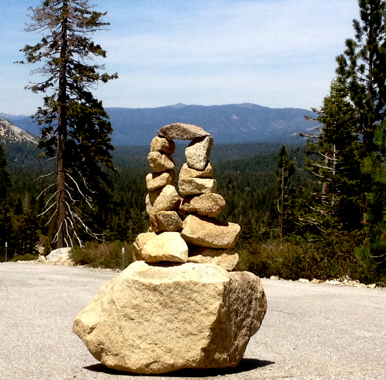
Tahoe Rock Cairns – Ancient Communication or Ancient Art?

Hike anywhere in Tahoe, especially in areas where you are not in a deep forest, and you will likely see a cairn, a small pile of rocks stacked up. They are designed to show you something, usually the correct path to take. Often on a hike, you will come to a juncture of sorts. It looks like the path goes two ways. Game trails can confuse, and natural formations can obscure the trail as well. Often, people will build a small cairn to mark the correct way to go.

Where did the path go? Oh, it's over here, around this tree.

In Tahoe, especially in the Desolation Wilderness, there are many trails that cross open areas of solid rock. When there is no way to discern the trail, you will usually find cairns that mark the path.
Just as cairns can be obvious or hard to find, their meaning can be obvious or hard to find. And sometimes, their meaning will elude you. You will think, is this a path? Or is there something else here that I'm supposed to notice? If you see a cairn that doesn't seem to show a path, consider that it might mark a hazard of some kind, an unseen drop-off, a slippery slope, something else that made a previous hiker think, “I should mark this so that others will notice.”
A cairn can say, "Climb up to this rise and see a great view."


Cairns have been around for as long as people. Scientists have dated many cairns back tens of thousands of years. Many mark burial sites.
Cairns can also be art. Often, people will make an elaborate cairn simply to be a beautiful object.
When a large boulder tumbled down onto Meyers Grade,
some kind hiker thought to make it into art for all of us to enjoy.

The next time you are hiking in Tahoe, keep a lookout for cairns. And if you come to a place where there should be a cairn and there isn't one, maybe you should add your mark to the world.


Sunday, May 12, 2013

Best Beaches In Tahoe - Sand Harbor


Sand Harbor – (Northeast corner of Tahoe)
Parking – Plenty, but always a good idea to get there early!
Fee - $12 per vehicle
Dogs – Sorry, not allowed, not even in vehicles!
Boat Launch – Yes


Tahoe has many classic, all-natural beaches with tons of sand and crystal-clear water, which, in August, can warm up to an almost tolerable temperature in the 60s.
Some of the classiest beaches of all are at Sand Harbor State Park off Highway 28 on the Nevada side of the lake about 3 miles south of Incline Village.

Sand Harbor is made up of a point of rocks and trees and sand that poke out into Lake Tahoe in a more prominent way than any other place on the shoreline. There is one very long beach facing south, a small and a medium beach facing north, and many little cozy areas tucked into hundreds of giant boulders that look like they were sprinkled onto the area by the Boulder gods.

Talk about clear water


Because of the way the the south-facing beach is protected, the water is often warmer, and you will likely see more people swimming at Sand Harbor than at any other beach on Tahoe.


The park has multiple restroom facilities, a store, and meeting areas that large groups can  rent, making it very comfortable.

Perhaps the most famous aspect of the park is its outdoor stage and natural amphitheater where the Lake Tahoe Shakespeare Festival is held everysummer. This year it is A Midsummer Night's Dream. Click here to get your tickets now.
 There is no other theatrical experience like it in the world. You sit under the stars watching your favorite of the Bard's delights.
Shakespeare on the beach is a great experience.

Behind the stage is the lake. Visible 20 miles away are the snow-capped mountains of the Desolation Wilderness looming over the West Shore.


Look closely down by the waterline, just right of center, and you
will see the rock slide at Emerald Bay (the gray triangle).
This is where the mountain slid away in 1955. 


There's a reason why Mt. Tallac is one of the most photographed mountains on the planet...

If you turn and look northwest, you can see the mountains of Alpine Meadows and Squaw Valley.
In the distance to the northwest are Alpine Meadows and Squaw Valley.


The boat-watching is great. Motor boats with skiers, sailboats and kayaks.


Kayaking Crystal Bay is like magic.


Sand Harbor is a unique and gorgeous spot that - sappy cliche here, but it's true - will give you a spiritual renewal. Highly recommended.

Sunday, May 5, 2013

Best Hikes In Tahoe - Cascade Falls


Cascade Falls (Southwest corner of Lake Tahoe)
Category – Easy, but for sure-footed, experienced hikers only. There are many tall steps and smooth rocks coated with slippery sand designed to make you slip and fall. I strongly recommend hiking boots with real tread. This is not a hike for casual shoes.
View Rating: 9 out of 10
1.5 miles round trip, little overall elevation gain, but sections of up and down.

Snow on the cirque between Mt. Tallac out of sight on the left and
Dicks Peak just behind the 9500-foot ridge in the center. Cascade Falls
is the white mark lower, center right

Everybody loves to go to Emerald Bay, see the Vikingsholm Castle, and hike to Eagle Falls. With its unique and spectacular beauty, Tahoe's only bay is deserving of its countless admirers.
But locals heading toward Emerald Bay often follow Frost's dictum and take the less traveled path out to Cascade Falls. You'll find fewer crowds, views nearly as grand as those at Emerald Bay, and literary antecedents that helped propel a writer toward an eventual Nobel Prize.
Emerald Bay and Cascade lake were formed by two parallel glaciers during the last Ice Age. The Emerald Bay glacier pushed all the way to Tahoe, forming a bay when it melted. The Cascade glacier pulled up short of the main lake, forming Cascade Lake.
Were Cascade Lake and the falls that tumble toward it in nearly any other state, it would be a state park, and freeway mileage signs would count down the distance as you drove the SUV packed with kids and hiking gear. Cascade Falls State Park 98 miles. Cascade Falls State Park 47 miles.
You get the idea. But because Cascade Falls is in Tahoe, it's just another amazing place with no highway signs announcing its presence.

The trail starts off as a pleasant stroll through the forest
Cascade Falls seen from the trail

We had lunch there May 1st. Because of the low snow year, the trail was free of white stuff a month early. Because it was a Wednesday in May, the trail was also free of people. Because the temps were in the 60s, the river and falls were gushing.
To get to the Cascade Falls trailhead, drive to Emerald Bay, but don't go to the popular parking lots for the Vikingsholm Castle or the lower one at the very head of the bay.
Instead, drive to the higher part of the highway south of the bay's head. The Bay View Campground – closed this early in the season – is on the mountain side of the highway, across from the Inspiration Point vista overlook. When the campground gate is closed, you can usually find a place to park near the highway. When the campground gate is open, drive through it to the end where there are several parking places and a trailhead sign just beyond.
Please note that, as with most hikes in Tahoe, it is best to go on weekdays, and parking is best found early in the day. Always resist the bright idea to go hiking late in the morning on Saturday!
There are two trails that depart from the trailhead sign area. The sign explains that you need to fill out a permit for a day hike in Desolation Wilderness, but that only applies to the right trail, which leads up to Maggie's Peaks and Desolation beyond.
Our trail to Cascade Falls is the left one, and you do not need a permit.

The trail has many large steps - not good if you have knee problems.

The trail winds through the woods heading south (where the sun is at 1 p.m. during Daylight Saving Time).
After a hundred yards or so, you come to the edge of the glacial moraine that forms the northwest side of Cascade Lake. The view over Cascade Lake is immediately spectacular.

Cascade Lake with Tahoe in the far distance

The trail goes along the side of the steep moraine slope. Cascade Falls will appear in the distance to the south. Lake Tahoe dominates in the distance to the northeast. Heavenly and the 10,900-foot Freel Peak massif spread out to the southeast.
As you approach the falls, you will be tempted by many beautiful places to sit on the rocks by the rushing water as you eat your lunch and maybe even dangle your feet in the ice water that only melted minutes before.
This is a fine idea but requires a word of warning. If you slip and fall in the water, you could be sent off the cliff. This especially applies to children and dogs etc. Enjoy your visit and all its beauty. But please don't become a statistic!
Looking down from the upper part of the falls

The rushing river above the falls
Lunch above Cascade Lake with Tahoe in the background

Stellar's Jays are beautiful but noisy birds. This one was looking for a handout that didn't come.
While you munch your lunch, ponder what it was like in 1926 when the 23-year-old John Steinbeck left Stanford and got a job working as a caretaker for the Brigham family estate on Cascade Lake. (The lake is still largely private, so we are very lucky to have a public trail to Cascade Falls.)
Steinbeck was a caretaker on Cascade Lake 1926-1928

Steinbeck worked on his first novel while snowed in during that first winter in Tahoe. From where you sit near the falls, you can look to the northeast end of Cascade Lake and visualize some of the locations that influenced Steinbeck's perceptions about landscape and loneliness.
Behind you is a large cirque of mountains leading up to the 9974-foot Dicks Peak. 
These are the snow fields that feed Cascade Falls. Look very closely
and you can see three avalanche tracks on the upper snow field.
The one on the upper right looks to be about 1000 feet long.

The cirque contains two good-sized lakes, Snow Lake and Azure Lake. They are scenic, but be aware that the trails to them are over bare rock and are not well marked. It is easy to get lost.
If all you do is have lunch at Cascade Falls, you will be well-rewarded. The round trip is short, but the views and memories will stay with you forever. Okay, not forever, but they'll occupy your neural synapses until you supplant those memories with your next amazing Tahoe experience.